
Hacia un Campus Universitario Inteligente. Caso de Estudio: Aplicación para la Movilidad Dentro del Campus Meléndez de la Universidad del Valle
Towards an Intelligent University Campus. Case Study: Application for Mobility Within the Meléndez Campus of the Universidad del Valle
Barra lateral del artículo
 FLIP
FLIP


Términos de la licencia (VER)

Esta obra está bajo una licencia internacional Creative Commons Atribución-NoComercial-SinDerivadas 4.0.
Declaración del copyright
Los autores ceden en exclusiva a la Universidad EIA, con facultad de cesión a terceros, todos los derechos de explotación que deriven de los trabajos que sean aceptados para su publicación en la Revista EIA, así como en cualquier producto derivados de la misma y, en particular, los de reproducción, distribución, comunicación pública (incluida la puesta a disposición interactiva) y transformación (incluidas la adaptación, la modificación y, en su caso, la traducción), para todas las modalidades de explotación (a título enunciativo y no limitativo: en formato papel, electrónico, on-line, soporte informático o audiovisual, así como en cualquier otro formato, incluso con finalidad promocional o publicitaria y/o para la realización de productos derivados), para un ámbito territorial mundial y para toda la duración legal de los derechos prevista en el vigente texto difundido de la Ley de Propiedad Intelectual. Esta cesión la realizarán los autores sin derecho a ningún tipo de remuneración o indemnización.
La autorización conferida a la Revista EIA estará vigente a partir de la fecha en que se incluye en el volumen y número respectivo en el Sistema Open Journal Systems de la Revista EIA, así como en las diferentes bases e índices de datos en que se encuentra indexada la publicación.
Todos los contenidos de la Revista EIA, están publicados bajo la Licencia Creative Commons Atribución-NoComercial-NoDerivativa 4.0 Internacional
Licencia
![]()
Esta obra está bajo una Licencia Creative Commons Atribución-NoComercial-NoDerivativa 4.0 Internacional
Contenido principal del artículo
Resumen
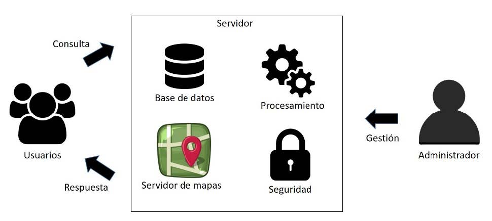
Desde el concepto de Ciudad Inteligente se abstrae a un modelo de Campus Inteligente, soportado por geoinformación y tecnologías de la información y la comunicación para generar una herramienta de apoyo a la movilidad dentro del Campus universitario. Las preguntas a resolver con la herramienta son: “en dónde queda”, y “cómo llego a”. Adoptando un Campus de 100 hectáreas y 18 kilómetros de caminos y vías, son dispuestos en una base de datos espacial para un Sistema de Información Geográfica y se dispone a través de una aplicación móvil y Web. Después de introducir los parámetros de la consulta al sistema, se construye la respuesta identificando el destino y cómo llegar a él, a través de la ruta más corta sobre el mapa base de la Universidad del Valle, la distancia entre los puntos origen-destino y el tiempo de recorrido para un peatón entre ellos. El Sig Web se desarrolló con Geoserver como servidor de mapas articulado con la librería Leaflet para JavaScript, usando un motor de base de datos PostgreSQL y PostGIS. Como resultado se construyó un SIG-Web y una aplicación móvil para sistemas operativos Android que funciona tanto en línea cómo sin conexión a Internet, desarrollada con framework Apache cordova y las librerías de framework7 y leaflet. UVManos es el nombre asignado a la aplicación Web y móvil, siendo un primer paso en la concepción de un Campus Inteligente con el cual toda una comunidad universitaria se localiza y mueve facilitando su desplazamiento dentro de la Universidad.
Descargas
Detalles del artículo
Citaciones


Referencias (VER)
Balram, S., & Dragicévic, S. (2006). Modeling Collaborative GIS Processes Using Soft Systems Theory, UML and Object Oriented Design. Transactions in GIS, 10(2), 199–218. Retrieved from http://www.omg.org
Benedito-Bordonau, M., Gallego Tarín, Di., Pere Avariento, J., Sanchis, A., Gould, M., & Huerta, J. (2014). UJI Smart Campus: Un ejemplo de integración de recursos en la Universitat Jaume I de Castelló. IV Jornadas Ibéricas de Infraestructuras de
Datos Espaciales, 1–12. https://doi.org/10.13140/RG.2.1.3362.6728
Chen, T. (2021). Smart campus and innovative education based on wireless sensor. Microprocessors and Microsystems, 81. https://doi.org/10.1016/j.micpro.2020.103678
De, D., Modelo, U. N., De, S., De Metadatos, B., Luna Ramírez’, E., Ambriz, H., … Mondragón, J. N. (2008). DESIGN OF A WEB SEMI-INTELLIGENT METADATA SEARCH MODEL APPLIED IN DATA WAREHOUSING SYSTEMS. In Revista chilena de ingeniería (Vol. 16).
Douglas Crockford. (2022, March 25). Introducción a JSON.
Esri Inc. (2022, March 25). Environmental Systems Research Institute.
Freire, C. E. de A., & Painho, M. (2014). Development of a Mobile Mapping Solution for Spatial Data Collection Using Open-Source Technologies. Procedia Technology, 16, 481–490. https://doi.org/10.1016/j.protcy.2014.10.115
Fu, T., & Karan, K. (2015). How Big is the World you can Explore? A Study of Chinese College Students’ Search Behavior via Search Engines. Procedia - Social and Behavioral Sciences, 174, 2743–2752. https://doi.org/10.1016/j.sbspro.2015.01.961
Giffinger, R., Gudrun, H., & Haindlmaier, G. (2010). Smart cities ranking: An effective instrument for the positioning of cities?POSITIONING OF CITIES? Año IV, 7–25. Retrieved from http://www-cpsv.upc.es/ace/Articles_n10/Articles_pdf/ACE_12_SA_10.pdfAccessUPCommons:http://hdl.handle.net/2099/8550
Greco, I., & Bencardino, M. (2014). LNCS 8580 - The Paradigm of the Modern City: SMART and SENSEable Cities for Smart,Inclusive and Sustainable Growth. In LNCS (Vol. 8580). Retrieved from https://link-springer-com.bd.univalle.edu.co/content/pdf/10.1007%2F978-3-319-09129-7_42.pdf
Hare, T. M., Rossi, A. P., Frigeri, A., & Marmo, C. (2018). Interoperability in planetary research for geospatial data analysis. Planetary and Space Science, 150, 36–42. https://doi.org/10.1016/j.pss.2017.04.004
Hobu Inc. (2022, March 25). draft-ietf-geojson-04 .
Koch, C., Neges, M., König, M., & Abramovici, M. (2014). Natural markers for augmented reality-based indoor navigation and facility maintenance. Automation in Construction, 48, 18–30. https://doi.org/10.1016/j.autcon.2014.08.009
Kowk, L.-F. (2015). A vision for the development of i-campus _ Enhanced Reader. Smart Learning Environments, 2(2), 1–12. Retrieved from https://slejournal.springeropen.com/articles/10.1186/s40561-015-0009-8
Moncrieff, S., Turdukulov, U., & Gulland, E. K. (2016). Integrating geo web services for a user driven exploratory analysis. ISPRS Journal of Photogrammetry and Remote Sensing, 114, 294–305. https://doi.org/10.1016/j.isprsjprs.2016.01.015
Olyazadeh, R., Sudmeier-Rieux, K., Jaboyedoff, M., Derron, M.-H., & Devkota2, S. (2017). An offline–online Web-GIS Android application for fast data acquisition of landslide hazard and risk. Nat. Hazards Earth Syst. Sci., 17, 549–561. Retrieved from https://nhess.copernicus.org/articles/17/549/2017/
OSGeo Project. (2022, March 25). GeoServer is an open source server for sharing geospatial data.
Owoc, M., & Mrciniak, K. (2013). Knowledge Management as Foundation of Smart University (Proceedings of the 2013 Federated Conference on Compueter Science and Information Systems, Ed.). Retrieved from https://ieeexplore-ieee-org.bd.univalle.edu.co/stamp/stamp.jsp?tp=&arnumber=6644177
Pluralsight. (2022, March 25). CELEBRATING 25 years of JavaScript.
PostGIS. (2022, March 25). Spatial and Geographic objects for PostgreSQL.
Quser Groups. (2022, March 25). QGIS Un Sistema de Información Geográfica libre y de Código Abierto.
Schnabel, O., & Hurni, L. (2009). CARTOGRAPHIC WEB APPLICATIONS-DEVELOPMENTS AND TRENDS. Proceedings of the 24th International Cartography Conference. Retrieved from https://icaci.org/files/documents/ICC_proceedings/ICC2009/html/nonref/13_4.pdf
Shao, D., Tan, X., Liu, H., Yang, H., Xiao, C., & Yang, F. (2013). Performance analysis of on-farm irrigation tanks on agricultural drainage water reuse and treatment. Resources, Conservation and Recycling, 75, 1–13. https://doi.org/10.1016/j.resconrec.2013.03.011
SQLite Consortium. (2022, March 25). SQLite .
Steiniger, S., & Bocher, E. (2009). An overview on current free and open source desktop GIS developments. International Journal of Geographical Information Science, 23(10), 1345–1370. https://doi.org/10.1080/13658810802634956
The Apache Software Foundation. (2022, March 25). Apache Cordova.
The Open Geospatial Consortium. (2022, March 25). The Home of Location Technology Innovation and Collaboration.
The PHP Group. (2022, March 25). PHP is a popular general-purpose scripting language that is especially suited to web development.
The PostgreSQL Global Development Group. (2022, March 25). PostgreSQL: The World’s Most Advanced Open Source Relational Database.
Torres-Sospedra, J., Avariento, J., Rambla, D., Montoliu, R., Casteleyn, S., Benedito-Bordonau, M., … Huerta, J. (2015). Enhancing integrated indoor/outdoor mobility in a smart campus. International Journal of Geographical Information Science, 29(11), 1955–1968. https://doi.org/10.1080/13658816.2015.1049541
Trilles, S., Calia, A., Belmonte, Ó., Torres-Sospedra, J., Montoliu, R., & Huerta, J. (2017). Deployment of an open sensorized platform in a smart city context. Future Generation Computer Systems, 76, 221–233. https://doi.org/10.1016/j.future.2016.11.005
Vladimir Agafonkin. (2022, March 25). Leaflet.
Vladimir Kharlampidi. (2022, March 25). Build full featured iOS, Android & Desktop apps.
Wirth, L. (2001). Revista de Estudios Sociales Leer la ciudad. Ensayos de Antropología Urbana El urbanismo como forma de vida * * *.
Zainuddin, K., Mokhtar, E. S. ., & Yusof, K. W. (2011). Developing a UiTM (Perlis) Web-Based of Building Space Management System_ A Preliminary Study in Locating a Specified Space_Room Area Using Open Source GIS Tool _ Elsevier Enhanced Reader. Procedia Engineering, 20(1), 154–158. https://doi.org/10.1016/J.PROENG.2011.11.150
Zavala-Romero, O., Ahmed, A., Chassignet, E. P., Zavala-Hidalgo, J., Fernández Eguiarte, A., & Meyer-Baese, A. (2014). An open source Java web application to build self-contained web GIS sites. Environmental Modelling and Software, 62, 210–220. https://doi.org/10.1016/j.envsoft.2014.08.029
Zhang, L., Liu, Y., Zhan, X., Yang, X., Chi, X., & Zhao, S. (2012). Campus View: An innovative location and context-aware video sharing application on smart phone. Wireless Personal Communications, 66(3), 493–509. https://doi.org/10.1007/s11277-012-0737-9
Zheng, J., Zhang, Z., Ciepluch, B., Winstanley, A. C., Mooney, P., & Jacob, R. (2013). A PostGIS-based pedestrian way finding module using OpenStreetMap data. International Conference on Geoinformatics. https://doi.org/10.1109/Geoinformatics.2013.6626049
Artículos similares
- Julián Andrés Salamanca Tellez, Lina Marcela Duque Becerra, Oscar Fernando Bedoya Leiva, cogniTherapy: una Aplicación Web para la Estimulación y Rehabilitación Cognitiva de Pacientes con Párkinson , Revista EIA: Vol. 22 Núm. 43 (2025): Tabla de contenido Revista EIA No. 43
También puede {advancedSearchLink} para este artículo.